United Arab Emirates |
Various tools available in Geographical Area Measurement Tool is expalined below. Change color of a selected region by choosing one color from color bar below |
|||


Local Weather of United Arab Emirates |
|||
 . Follow read more to view United Arab Emirates live weather forecast on Google satellite maps.
谷歌卫星地图 安道尔 |
|||
Mapas de satélite do Google de United Arab Emirates |
|||
 .Siga ler mais para ver mapas do Google por satélite.
Google satellite maps of United Arab Emirates |
|||
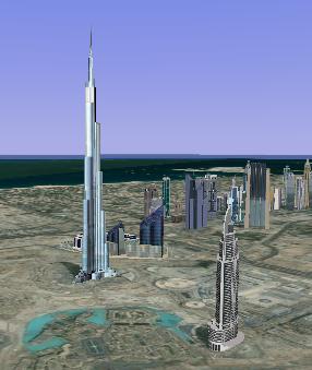
Burj Khalifa Skyscaper, Dubai(دبي) image (Tower of Burj Khalifa former Burj Dubai tower) |
|||

* Dubai at night Images, Videos, Google Earth 3d view/aerial satellite map view/hybrid satellite maps/road map of Maritime City, Dubai - United Arab Emirates (الصور وأشرطة الفيديو، برنامج Google Earth 3D رأي / جوي عرض الخريطة الفضائية / خرائط الأقمار الصناعية المختلطة / خارطة الطريق من المدينة البحرية، دبي - الامارات العربية المتحدة) follows |
|||

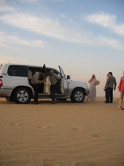
* Stopping during desert safari for viewing sunset Images, Videos, Google Earth 3d view/aerial satellite map view/hybrid satellite maps/road map of Global Village Dubai, United Arab Emirates follows |
|||
The World is an artificial archipelago of various small islands constructed in the rough shape of a map of the landmasses of the Earth, located 4 km from the coast of Dubai, United Arab Emirates. The World islands are composed mainly of sand dredged from Dubai's shallow coastal waters, and are one of several artificial island developments in Dubai. The World's developer is Nakheel Properties, and the project was originally conceived by Sheikh Mohammed bin Rashid Al Maktoum, the ruler of Dubai. Google Earth 3d view/aerial satellite map view/hybrid satellite maps/road map of The World Dubai follows |
|||
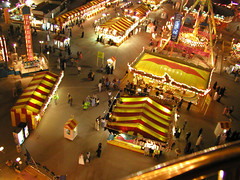
Dubai Shopping Festival (DSF) started on February 15, 1996 as a retail event as a government initiation to to revitalise retail trade in Dubai, United Arab Emirates. It is later expanded with support from dubai commercial ventures and tourist support ventures as a main tourist attraction to dubai. DSF is a month long event conducted every year and is usually scheduled during the first quarter of the year, attracting about 3-4 million people to Dubai. This year the month long Dubai Shopping Festival started on today 28-1-2010. dubai shopping festival global village images
|
|||
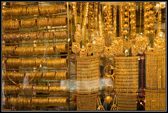
gold displayed in a shop in gold souk, dubai
|
|||
|
|||


