|
|
|
|
|
|
Submitted by jaxo on Sat, 06/26/2010 - 19:15
|
google earth maps/ google satellite maps/hybrid view of cape town south africa airport.
|
|
|
|
|
|
|
|
|
|
Submitted by yezzbi on Thu, 06/10/2010 - 01:30
|
Google Earth 3d view/ aerial satellite map view/ hybrid satellite maps/ road map of mbombela stadium, nelspruit, south africa
|
|
|
|
|
|
|
|
|
|
Submitted by yezzbi on Thu, 06/10/2010 - 01:16
|
Google streetview of Royal Bafokeng Stadium, Rustenburg, South Africa
|
|
|
|
|
|
|
|
|
|
Submitted by yezzbi on Thu, 06/10/2010 - 00:51
|
Google Street view of Peter Mokaba Stadium, Polokwane from within stadium
|
|
|
|
|
|
|
|
|
|
Submitted by yezzbi on Wed, 06/09/2010 - 23:39
|
Google Earth 3d view/ aerial satellite map view/ hybrid satellite maps/ road map of bloemfontein south africa free state stadium
|
|
|
|
|
|
|
|
|
|
Submitted by yezzbi on Wed, 06/09/2010 - 22:42
|
Google Earth 3d view/ aerial satellite map view/ hybrid satellite maps/ road map of nelson mandela bay stadium,6001, port elizabeth , south africa
|
|
|
|
|
|
|
|
|
|
Submitted by yezzbi on Mon, 06/07/2010 - 00:01
|
Google Earth 3d view/aerial satellite map view/hybrid satellite maps/road map of Loftus Versfeld Soccer Stadium, Pretoria 0002, South Africa
|
|
|
|
|
|
|
|
|
|
Submitted by yezzbi on Sun, 06/06/2010 - 23:23
|
Google Earth 3d view/aerial satellite map view/hybrid satellite maps/road map of Ellis Park Soccer Stadium - Parking Area, 44 Staib St, Johannesburg 2094, South Africa
|
|
|
|
|
|
|
|
|
|
Submitted by yezzbi on Sun, 06/06/2010 - 22:43
|
Google Earth 3d view/aerial satellite map view/hybrid satellite maps/road map of Green Point Stadium, Cape Town 8005, South Africa
|
|
|
|
|
|
|
|
|
|
Submitted by yezzbi on Sun, 06/06/2010 - 22:16
|
Google Earth 3d view/aerial satellite map view/hybrid satellite maps/road map of Moses Mabhida Stadium, Durban 4001, South Africa
|
|
|
|
|
|
|
|
|
|
Submitted by yezzbi on Sun, 06/06/2010 - 21:29
|
Google Earth 3d view/aerial satellite map view/hybrid satellite maps/road map of F.N.B. Soccer City Soccer Stadium, Johannesburg, South Africa
|
|
|
|
|
|
|
|
|
|
Submitted by jos on Sat, 05/08/2010 - 11:50
|
Location of Denver International airport
|
|
|
|
|
|
|
|
|
|
Submitted by joy on Sat, 05/08/2010 - 11:37
|
Glendale airport location in us map

|
|
|
|
|
|
|
|
|
|
Submitted by raymundo on Sat, 05/08/2010 - 11:17
|
University of Phoenix Stadium Road map

University of Phoenix Stadium Image
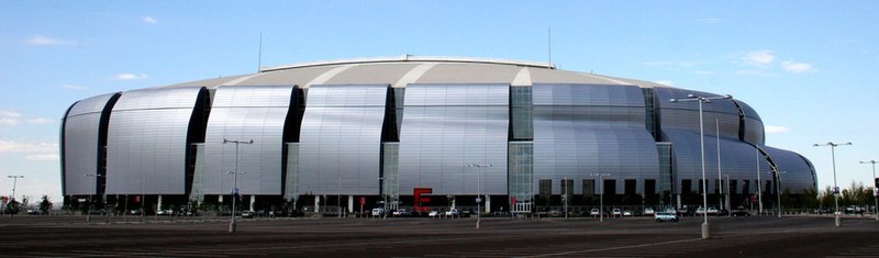
Google Earth 3d view/satellite maps aerial view/map view of university of Phoenix
|
|
|
|
|
|
|
|
|
|
Submitted by Ria on Sat, 05/08/2010 - 10:57
|
|
|
|
|
|
|
|
|
|
|
Submitted by Ria on Wed, 04/28/2010 - 00:45
|

University of Hawaii at manoa
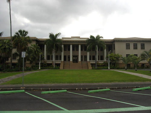
location of University of hawaii manao in hawaii

University of Hawaii at Manao
Google Earth 3d view/google road map/google satellite view/hybrid maps of University of Hawaii at Manao
|
|
|
|
|
|
|
|
|
|
Submitted by Ria on Wed, 04/28/2010 - 00:13
|
Google Earth 3d view/google road map/google satellite view/hybrid maps of University of Hawaii at Hilo UHH
|
|
|
|
|
|
|
|
|
|
Submitted by rogersqmonty on Mon, 04/26/2010 - 23:11
|
Google Earth adalah sebuah dunia virtual 3d, peta, geografis sistem informasi yang diberikan sebagai layanan gratis dan berbayar layanan dengan pencarian mesin raksasa Google.
|
|
|
|
|
|
|
|
|
|
Submitted by joy on Thu, 04/22/2010 - 01:21
|
Location of Hawaii in world map

|
|
|
|
|
|
|
|
|
|
Submitted by jos on Thu, 04/22/2010 - 01:10
|
location of Honolulu international airport

|
|
|
|
|
|
|
|
|
|
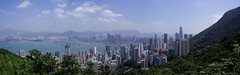
Submitted by RIdave on Thu, 04/22/2010 - 00:03
|
Hong Kong (in Chinese: 香港) is one of the most densely populated areas in the world Situated on China's south coast and enclosed by the Pearl River Delta and South China Sea, With land mass of 1,104 km2 (426 sq mi) and a population of seven million people attracted to live in Hong kong by its expansive skyline and deep natural harbour. Hong kong is one of two special administrative regions of the People's Republic of China, the other being Macau.
|
|
|
|
|
|
|
|
|
|
Submitted by hoesein on Wed, 04/21/2010 - 23:47
|

Amman (pronounced /ɑːˈmɑːn/; Arabic: عمّان, ʿAmmān) is the capital and largest city of the Hashemite Kingdom of Jordan. A city of about 2 million inhabitants , it is the Jordan's political, cultural and commercial centre and one of the oldest continuously inhabited cities in the world.
|
|
|
|
|
|
|
|
|
|
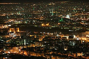
Submitted by hoesein on Wed, 04/21/2010 - 23:15
|
Damascus (Arabic: دِمَشقُ, Dimashq, commonly known as الشام ash-Shām also known as the "City of Jasmin" Arabic: مدينة الياسمين Madīnatul Yāsmīn) is the capital and largest city of Syria as well as considered as oldest continuously inhabited city in the world, Damascus is a major cultural and religious center.
Damascus at night image
|
|
|
|
|
|
|
|
|
|
Submitted by rahmat on Thu, 04/08/2010 - 12:17
|
Singapore Google Earth 3d map/google satellite map/hybrid map/satellite map view
|
|
|
|
|
|
|
|
|
|
Submitted by Ria on Thu, 04/08/2010 - 11:49
|
Google Earth Maps pandangan satelit Malaysia
Google Earth Malaysia
|
|
|
|
|
|
|
|
|
|
Submitted by Ramkumar on Thu, 04/08/2010 - 11:30
|
|
|
|
|
|
|
|
|
|
|
Submitted by Ria on Thu, 04/08/2010 - 11:18
|
Google Earth philipines
(Google Earth Maps Pilipinas Satellite/Google Earth Filipinas mapas de satélite)
|
|
|
|
|
|
|
|
|
|
Submitted by Ria on Sun, 04/04/2010 - 18:27
|
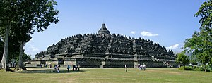
Candi Borobudur Images
The main Stupa of borobudur, the largest Buddhist monastry in the world

Borobudur temple view from northeast
|
|
|
|
|
|
|
|
|
|
Submitted by admin28k on Sun, 04/04/2010 - 12:58
|
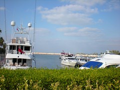
Jebel Ali dubai sea port
|
|
|
|
|
|
|
|
|
|
Submitted by Ramkumar on Sun, 04/04/2010 - 12:31
|
In order to get Google Earth 3d view click the "earth" button. To get google earth view google earth plugin is required, if not yet installed in your system, installation prompt will come, install and click refresh.
|
|
|
|
|

|
|

