|
|
|
|
|
Local Weather of Indonesia  . Follow read more to view Indonesia live weather forecast on Google satellite maps. . Follow read more to view Indonesia live weather forecast on Google satellite maps.
|
|
|
|
|
|
|
|
|
谷歌卫星地图 印尼 . 按照阅读更多 谷歌查看 印尼 的卫星地图。
|
|
|
|
|
|
|
|
|
Google satellite maps of Indonesia . Follow read more to view Indonesia Google satellite maps.
|
|
|
|
|
|
|
|
|
Indonesian Rupiah is currency used in Indonesia
Indonesian Rupiah Currency And Exchange
|
|
|
|
|
|
|
|
|
|
Submitted by Jackie on Mon, 03/07/2011 - 00:41
|
3d view/aerial satellite map view/ / map of Singapore International School, Jalan Gandaria, Jakarta 12240, Indonesia
|
|
|
|
|
|
|
|
|
|
Submitted by yezzbi on Mon, 03/07/2011 - 00:24
|
3d view/aerial satellite map view/ of Padang Golf in Pandak Indah. Pondok Indah is a much sought after rich residential area near singapore International School, Jalan Gandaria, Jakarta Capital Region , Indonesia
|
|
|
|
|
|
|
|
|
|
Submitted by joy on Mon, 03/07/2011 - 00:09
|
3d view/aerial satellite map view/ / map of Jalan Metro Pondok Indah, Jakarta Capital Region 12310, Indonesia
|
|
|
|
|
|
|
|
|
|
Submitted by joy on Sun, 03/06/2011 - 23:49
|
3d view/aerial satellite map view/ / map of Cirebon, Indonesia
|
|
|
|
|
|
|
|
|
|
Submitted by Ria on Tue, 08/31/2010 - 01:41
|
Wonosobo is a regency in central java province of Indonesia which is located in Dieng Plateau about 120km from semarang .
|
|
|
|
|
|
|
|
|
|
Submitted by Ramkumar on Tue, 08/31/2010 - 00:57
|
Mount Rinjani or Gunung Rinjani on the island of Lombok West Nusa Tenggara (NTB)is an active volcano in Indonesia. It has high height of 3,726 metres (12,224 ft),being the second highest volcano in Indonesia.
Its 6 km long 8.5 km width oval-shaped caldera containing hot springs is filled partially by 200 meter depth crater lake known as Segara Anak ('Child of the Sea'). This lake is approximately 2000 metres above sea level.
Google Earth 3d view/ satellite map view/hybrid satellite maps/road map of Mount Rinjani.
|
|
|
|
|
|
|
|
|
|
Submitted by jos on Tue, 08/31/2010 - 00:27
|
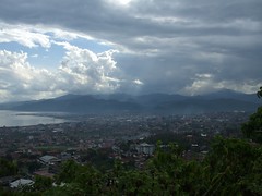
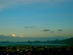
Lake Maninjau in Indonesian language called Danau Maninjau, means overlook or observation is a caldera crater formed lake in West Sumatra, Indonesia. It is 16 km near to the city of Bukittinggi in Sumatra. It is estimated to have formed 50000 years ago and has 20x8 km length and width.People who live are mostly ethnic Minangkabau.Lake Maninjau is used for hydro electric power generation and has aquaculture farm production. Lake Maninjau is big tourist attraction in the region because of its splendid scenic beauty. Sport activities like trekking paragliding attracts adventurists too.
Google Earth 3d view/ satellite map view/hybrid satellite maps/road map of Lake Maninjau.
|
|
|
|
|
|
|
|
|
|
Submitted by Ramkumar on Mon, 08/30/2010 - 23:47
|
jam gadang big clock tower in Bukittinggi, as shown in google earth
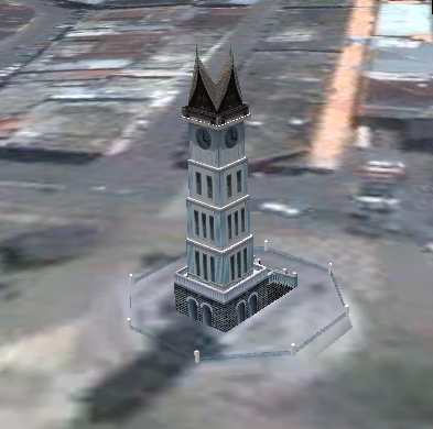
Bukittinggi means in Indonesian language "high hill" is one of the larger cities in West Sumatra, Indonesia, which is 90 km by road distance from the West Sumatran capital city of Padang. It is having a population of over 91,000 people and an area of 25.24 km².
It is a city popular with tourists due to the climate and easy accessibility. Attractions within and around the city follows:
*Sianok Canyon
* Ngarai Sianok (Sianok Canyon)
* Lobang Jepang (Japanese Caves) - a network of underground bunkers and tunnels built by the Japanese during World War II
* Jam Gadang - a large clock tower built by the Dutch .
* Taman Bundo Kanduang park. The Dutch hilltop outpost Fort de Kock is connected to the zoo by the Limpapeh pedestrian pass.
* Museum Rumah Kelahiran Bung Hatta, the house where Indonesian founding father Mohammad Hatta was born, now a museum.
Nearby Tourist attractions include Lake Maninjau and the Harau Valley.
Google Earth 3d view/ satellite map view/hybrid satellite maps/road map of Bukittinggi, Indonesia
|
|
|
|
|
|
|
|
|
|
Submitted by rahmat on Mon, 08/30/2010 - 22:58
|
Google Earth 3d view/ satellite map view/hybrid satellite maps/road map of Mt Bromo, Sukapura.
|
|
|
|
|
|
|
|
|
|
Submitted by jos on Mon, 08/30/2010 - 22:34
|
Wikimapia satellite map of Bekasi of west java island in Indonesia
|
|
|
|
|
|
|
|
|
|
Submitted by Ria on Mon, 08/30/2010 - 22:11
|
Google Earth 3d view/aerial satellite map view/hybrid /road map of West Java(sudanese:Kulon,also called Jabar), Indonesia
|
|
|
|
|
|
|
|
|
|
Submitted by Ramkumar on Mon, 08/30/2010 - 21:44
|
Google Earth 3d view/aerial satellite map view/hybrid satellite maps/road map of Central Java (Indonesian name java Tengah) of Indonesia which is one of the six provinces in island of jawa
|
|
|
|
|
|
|
|
|
|
Submitted by Ria on Sun, 04/04/2010 - 18:27
|
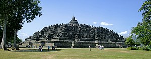
Candi Borobudur Images
The main Stupa of borobudur, the largest Buddhist monastry in the world

Borobudur temple view from northeast
|
|
|
|
|
|
|
|
|
|
Submitted by Ramkumar on Mon, 03/22/2010 - 01:56
|
Inorder to see in google earth view, click on the google earth button of following map. Google earth plugin is required for getting 3D view, if it is not installed in your browser, it will be prompted to install, please install it and the google earth view will be visible, Also you can do local search of manado from the search bar
|
|
|
|
|
|
|
|
|
|
Submitted by rahmat on Mon, 03/22/2010 - 01:37
|
Inorder to see in google earth view, click on the google earth button of following map. Google earth plugin is required for getting 3D view, if it is not installed in your browser, it will be prompted to install, please install it and the google earth view will be visible.
|
|
|
|
|
|
|
|
|
|
Submitted by Ria on Mon, 03/22/2010 - 01:19
|
Google Earth Map of Makassar in Indonesia is given below
|
|
|
|
|
|
|
|
|
|
Submitted by yezzbi on Sat, 02/06/2010 - 02:16
|
Inorder to see in google earth view, click on the google earth button of following map.
|
|
|
|
|
|
|
|
|
|
Submitted by FatBadSharK on Sat, 02/06/2010 - 02:10
|
Inorder to see in google earth view, click on the google earth button of following map.
|
|
|
|
|
|
|
|
|
|
Submitted by jaxo on Sat, 02/06/2010 - 02:04
|
Inorder to see in google earth view, click on the google earth button of following map.
|
|
|
|
|
|
|
|
|
|
Submitted by tedy on Sat, 02/06/2010 - 01:56
|
Inorder to see in google earth view, click on the google earth button of following map.
|
|
|
|
|
|
|
|
|
|
Submitted by jaswant on Sat, 02/06/2010 - 01:49
|
Inorder to see in google earth view, click on the google earth button of following map.
|
|
|
|
|
|
|
|
|
|
Submitted by jaxo on Sat, 02/06/2010 - 01:42
|
Inorder to see in google earth view, click on the google earth button of following map.
|
|
|
|
|
|
|
|
|
|
Submitted by rgrigor on Sun, 11/15/2009 - 17:26
|
Lampung is a province of Indonesia, located on the southern tip of the island of Sumatra. which borders with provinces of Bengkulu and South Sumatra. Lampung name come from the "Lampung" tribe, who speak a distinct language from other people in Sumatra and have their own alphabet. A large portion of the current population of Lampung is descended from migrants from Java, Madura, and Bali.
Lampung is often heard for its earthquakes and volcanoes. On May 10 2005, a strong earthquake measuring 6.4 on the richter scale struck the province. The historical volcano blast of Krakatau occurred in 1883, which resulted in disastrous consequences.
TGK Air Port Lampung
|
|
|
|
|
|
|
|
|
|
Submitted by jos on Sun, 11/15/2009 - 16:42
|
Balikpapan is a seaport city on the eastern coast of Borneo island, Indonesia in the East Kalimantan province, a resource-rich region well known for its timber, mining and petroleum export products.
|
|
|
|
|
|
|
|
|
|
Submitted by neorceDon on Mon, 10/12/2009 - 01:50
|
borneo map showing where borneo located and Political divisions of Borneo
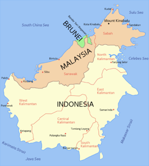
The Tip Of Borneo
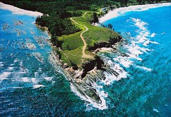
rest of post follows, click read more to see
|
|
|
|
|
|
|
|
|
|
Submitted by rooster.1180 on Mon, 10/12/2009 - 01:45
|
Google satellite map view of Lombok island in indonesia
|
|
|
|
|

|
|

