|
|
|
|
|
|
Submitted by rahmat on Wed, 03/03/2010 - 22:57
|
Google earth map showing Pebble beach golf links is given below, click read more to visit this place.
|
|
|
|
|
|
|
|
|
|
Submitted by rahmat on Wed, 03/03/2010 - 22:46
|
Google earth map showing The honorable company of edinburgh golfers follows
|
|
|
|
|
|
|
|
|
|
Submitted by Ria on Wed, 03/03/2010 - 22:41
|
Google earth map showing Oakmont Country Club,1233 Hulton Road,Oakmont, Penssylvania, USA follows
|
|
|
|
|
|
|
|
|
|
Submitted by Ria on Wed, 03/03/2010 - 22:33
|
Google earth map showing Turnberry,Maidens Road,Ayrshire, KA26 9LT,scotland, United Kingdom follows
|
|
|
|
|
|
|
|
|
|
Submitted by Ria on Wed, 03/03/2010 - 22:28
|
Google earth map showing Augusta national golf club, augusta, georgia follows
|
|
|
|
|
|
|
|
|
|
Submitted by admin on Wed, 03/03/2010 - 22:21
|
Google earth map showing southampton golf course follows
|
|
|
|
|
|
|
|
|
|
Submitted by rahmat on Wed, 03/03/2010 - 19:36
|
Google earth map showing shinnecock hills golf club,200 Tuckahoe Road,Southampton, New York (NY) 11968,USA follows
|
|
|
|
|
|
|
|
|
|
Submitted by jaxo on Wed, 03/03/2010 - 19:29
|
Google earth map showing Royal county down golf club, 36 Golf Links Rd, Newcastle, Co. Down, BT33 0AN, Northern Ireland follows
|
|
|
|
|
|
|
|
|
|
Submitted by Ramkumar on Wed, 03/03/2010 - 19:22
|
To get google earth view click the earth tab in the following google map. In order to get google earth 3d view it is required to install google earth plugin, if already not installed your computer, browser will prompt to install the plugin, install the plugin to get the google earth maps.
By default the google satellite hybrid view is the one which is enabled, one can see the street maps or satellite maps only by selecting respective tabs.
Google earth map showing many newcastle golf courses below
|
|
|
|
|
|
|
|
|
|
Submitted by rahmat on Wed, 03/03/2010 - 19:16
|
To get google earth view click the earth tab in the following google map. In order to get google earth 3d view it is required to install google earth plugin, if already not installed your computer, browser will prompt to install the plugin, install the plugin to get the google earth maps.
By default the google satellite hybrid view is the one which is enabled, one can see the street maps or satellite maps only by selecting respective tabs.
Google earth map of pine valley golf club golf course, clementon, New jersey, USA follows
|
|
|
|
|
|
|
|
|
|
Submitted by Ria on Wed, 03/03/2010 - 19:10
|
To get google earth view click the earth tab in the following google map.
|
|
|
|
|
|
|
|
|
|
Submitted by Ria on Wed, 03/03/2010 - 19:00
|
Tiger woods in Action

Visit famous golf courses virtually with google earth to have an aerial look of golf courses.
|
|
|
|
|
|
|
|
|
|
Submitted by Ria on Tue, 02/16/2010 - 02:02
|
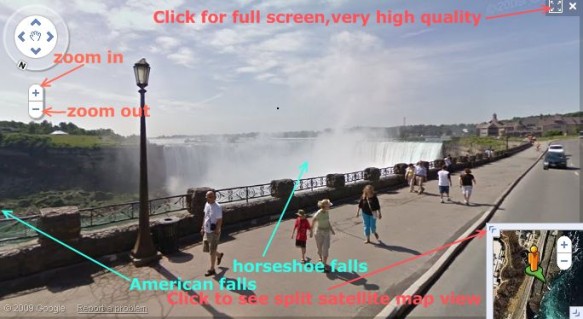
Google has made available its popular street view service in niagra falls region in canada.
A snapshot from google street view showing the niagra horse shoe falls in canada
google streetview image showing niagra falls in america (american falls and bridal veil falls), also is visible the rainbow bridge across niagra river
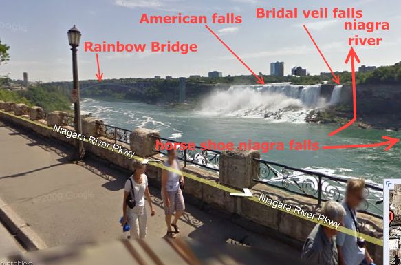
click read more to see the google street veiw of niagra falls.
|
|
|
|
|
|
|
|
|
|
Submitted by yezzbi on Sat, 02/06/2010 - 02:16
|
Inorder to see in google earth view, click on the google earth button of following map.
|
|
|
|
|
|
|
|
|
|
Submitted by FatBadSharK on Sat, 02/06/2010 - 02:10
|
Inorder to see in google earth view, click on the google earth button of following map.
|
|
|
|
|
|
|
|
|
|
Submitted by jaxo on Sat, 02/06/2010 - 02:04
|
Inorder to see in google earth view, click on the google earth button of following map.
|
|
|
|
|
|
|
|
|
|
Submitted by tedy on Sat, 02/06/2010 - 01:56
|
Inorder to see in google earth view, click on the google earth button of following map.
|
|
|
|
|
|
|
|
|
|
Submitted by jaswant on Sat, 02/06/2010 - 01:49
|
Inorder to see in google earth view, click on the google earth button of following map.
|
|
|
|
|
|
|
|
|
|
Submitted by jaxo on Sat, 02/06/2010 - 01:42
|
Inorder to see in google earth view, click on the google earth button of following map.
|
|
|
|
|
|
|
|
|
|
Submitted by admin on Mon, 01/18/2010 - 03:46
|
gold displayed in a shop in gold souk, dubai

|
|
|
|
|
|
|
|
|
|
Submitted by jos on Mon, 01/18/2010 - 02:48
|
Dubai Shopping Festival DSF will commense on 28th january 2010. Just 10 more days to go for this month long annual dubai shopping festival. DSF is a premier shopping event in the region famous offers,gifts, bonuses and promotional events.
An image of Dubai festival city

Another image of Dubai festival center water front

Google earth / satellite map view of The Dubai Festival city follows.
|
|
|
|
|
|
|
|
|
|
Submitted by admin on Mon, 01/18/2010 - 02:36
|
The man made islands of dubai, The palms: Palm Jumeira
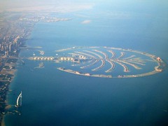
Google earth view of The man made Palm Dubai island, Palm Jumeira follows.
|
|
|
|
|
|
|
|
|
|
Submitted by Ria on Mon, 01/18/2010 - 02:16
|

Google earth map follows
|
|
|
|
|
|
|
|
|
|
Submitted by admin on Mon, 01/18/2010 - 01:50
|
Aerial Satellite view of Taiwan
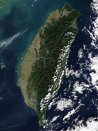
Image showing administrative divisions of Tailand

Google earth view of Taiwan follows
|
|
|
|
|
|
|
|
|
|
Submitted by admin on Mon, 11/16/2009 - 00:20
|
Images of niagra falls taken using google earth map embedded below


|
|
|
|
|
|
|
|
|
|
Submitted by admin on Sun, 11/15/2009 - 22:57
|
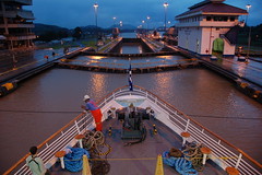
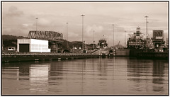
The Panama Canal Miraflores Locks
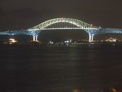
Bridge of the Americas, Panama
A schematic map of the Panama Canal, illustrating the sequence of locks and passages

The Panama Canal
|
|
|
|
|
|
|
|
|
|
Submitted by rgrigor on Sun, 11/15/2009 - 17:26
|
Lampung is a province of Indonesia, located on the southern tip of the island of Sumatra. which borders with provinces of Bengkulu and South Sumatra. Lampung name come from the "Lampung" tribe, who speak a distinct language from other people in Sumatra and have their own alphabet. A large portion of the current population of Lampung is descended from migrants from Java, Madura, and Bali.
Lampung is often heard for its earthquakes and volcanoes. On May 10 2005, a strong earthquake measuring 6.4 on the richter scale struck the province. The historical volcano blast of Krakatau occurred in 1883, which resulted in disastrous consequences.
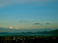
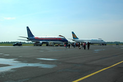
TGK Air Port Lampung
|
|
|
|
|
|
|
|
|
|
Submitted by jos on Sun, 11/15/2009 - 16:42
|
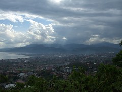
Balikpapan is a seaport city on the eastern coast of Borneo island, Indonesia in the East Kalimantan province, a resource-rich region well known for its timber, mining and petroleum export products.
|
|
|
|
|
|
|
|
|
|
Submitted by Ria on Fri, 11/06/2009 - 23:46
|
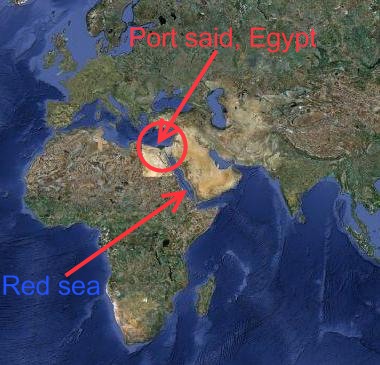
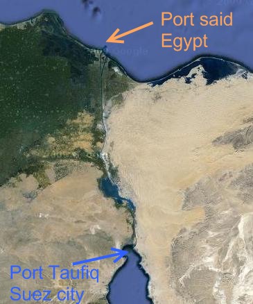
Port said in Egypt is northern terminus of suez canal.
|
|
|
|
|
|
|
|
|
|
Submitted by rahmat on Fri, 11/06/2009 - 21:40
|
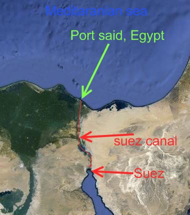
The Suez Canal is an artificial sea-level waterway connecting the Mediterranean Sea and the Red Sea located in Egypt. Opened on November 1869, it allows shortest water transportation between Europe and Asia avoiding the requirement of navigating around Africa. The northern terminus is Port Said and the southern terminus is Port Tawfik at the city of Suez.
Suez canal map
|
|
|
|
|

|
|


