|
|
|
|
|
|
Submitted by jos on Tue, 10/25/2011 - 05:22
|
3d view/aerial satellite map view/hybrid / map of Hamilton City and Hamilton urban Area of Newzealand
|
|
|
|
|
|
|
|
|
|
Submitted by joy on Mon, 10/24/2011 - 01:50
|
Google Earth 3d view/aerial satellite map view/hybrid satellite maps/road map of Sirte, Libya
|
|
|
|
|
|
|
|
|
|
Submitted by jos on Mon, 03/07/2011 - 01:51
|
3d view/aerial satellite map view/ / map of Wellington, New Zealand
|
|
|
|
|
|
|
|
|
|
Submitted by jos on Mon, 03/07/2011 - 01:38
|
Earth 3d view/aerial satellite map view/ satellite / map of Ayers rock (Uluru),
|
|
|
|
|
|
|
|
|
|
Submitted by Magyar on Mon, 03/07/2011 - 01:08
|
3d view/aerial satellite map view/ / map of Gisborne, New Zealand
|
|
|
|
|
|
|
|
|
|
Submitted by Jackie on Mon, 03/07/2011 - 00:41
|
3d view/aerial satellite map view/ / map of Singapore International School, Jalan Gandaria, Jakarta 12240, Indonesia
|
|
|
|
|
|
|
|
|
|
Submitted by yezzbi on Mon, 03/07/2011 - 00:24
|
3d view/aerial satellite map view/ of Padang Golf in Pandak Indah. Pondok Indah is a much sought after rich residential area near singapore International School, Jalan Gandaria, Jakarta Capital Region , Indonesia
|
|
|
|
|
|
|
|
|
|
Submitted by joy on Mon, 03/07/2011 - 00:09
|
3d view/aerial satellite map view/ / map of Jalan Metro Pondok Indah, Jakarta Capital Region 12310, Indonesia
|
|
|
|
|
|
|
|
|
|
Submitted by joy on Sun, 03/06/2011 - 23:49
|
3d view/aerial satellite map view/ / map of Cirebon, Indonesia
|
|
|
|
|
|
|
|
|
|
Submitted by rahmat on Sat, 03/05/2011 - 23:39
|
is second largest city of , Recently was in news because of Earch quakes occurred at this place. An earthquake of magnitude 6.3 occurred on 22 February 2011 at 12:51pm, epicenter on Lyttelton 10 kilometres south east at a depth of 5 km, resulted in 165 total casualities, and wide spread damage to buildings occurred.
The ground shaking as result of this quake is considered as one of the strongest ever recorded globally, because of the proximity and shallowness of epicenter and caused loss of water, power and sewage throughout the city. For the first time a National State of Emergency was declared to tackle the situation.
Even though had an earth quake of higher magnitude at 7.1 in the South Island, on Saturday 04:35 am local time, 4 September 2010, the earthquake occurred at a depth of 10 kilometres (6.0 miles), and there were no fatalities.
Earth 3d view/aerial satellite map view/hybrid satellite maps/road map of Christchurch,
|
|
|
|
|
|
|
|
|
|
Submitted by jos on Sat, 03/05/2011 - 01:45
|
Google Earth 3d view/aerial satellite map view/hybrid /road map of Auckland, New Zealand
|
|
|
|
|
|
|
|
|
|
Submitted by jos on Sat, 03/05/2011 - 01:12
|
Google Earth 3d view/aerial satellite map view/hybrid /road map of Libya
|
|
|
|
|
|
|
|
|
|
Submitted by jos on Sat, 03/05/2011 - 01:02
|
3d view/aerial satellite map view/hybrid /road map of Oman
|
|
|
|
|
|
|
|
|
|
Submitted by Ria on Tue, 08/31/2010 - 01:41
|
Wonosobo is a regency in central java province of Indonesia which is located in Dieng Plateau about 120km from semarang .
|
|
|
|
|
|
|
|
|
|
Submitted by jos on Mon, 08/30/2010 - 22:34
|
Wikimapia satellite map of Bekasi of west java island in Indonesia
|
|
|
|
|
|
|
|
|
|
Submitted by Ria on Mon, 08/30/2010 - 22:11
|
Google Earth 3d view/aerial satellite map view/hybrid /road map of West Java(sudanese:Kulon,also called Jabar), Indonesia
|
|
|
|
|
|
|
|
|
|
Submitted by Ramkumar on Mon, 08/30/2010 - 21:44
|
Google Earth 3d view/aerial satellite map view/hybrid satellite maps/road map of Central Java (Indonesian name java Tengah) of Indonesia which is one of the six provinces in island of jawa
|
|
|
|
|
|
|
|
|
|
Submitted by jos on Tue, 07/27/2010 - 00:34
|
Google Earth 3d view/aerial satellite map view/hybrid satellite maps/road map of Luxor, Al - Uqsur, Qena, Egypt
|
|
|
|
|
|
|
|
|
|
Submitted by jos on Tue, 07/27/2010 - 00:21
|
Google Earth 3d view/aerial satellite map view/hybrid satellite maps/road map of Cairo, Egypt
|
|
|
|
|
|
|
|
|
|
Submitted by jos on Tue, 07/27/2010 - 00:08
|
Google Earth 3d view/aerial satellite map view/hybrid satellite maps/road map of Egypt
|
|
|
|
|
|
|
|
|
|
Submitted by jos on Mon, 07/26/2010 - 02:40
|
The World is an artificial archipelago of various small islands constructed in the rough shape of a map of the landmasses of the Earth, located 4 km from the coast of Dubai, United Arab Emirates. The World islands are composed mainly of sand dredged from Dubai's shallow coastal waters, and are one of several artificial island developments in Dubai. The World's developer is Nakheel Properties, and the project was originally conceived by Sheikh Mohammed bin Rashid Al Maktoum, the ruler of Dubai.
Google Earth 3d view/aerial satellite map view/hybrid satellite maps/road map of The World Dubai follows
|
|
|
|
|
|
|
|
|
|
Submitted by jos on Sun, 07/25/2010 - 00:46
|
|
|
|
|
|
|
|
|
|
|
Submitted by jos on Sun, 07/25/2010 - 00:30
|
Sunrise of New Year 2009 at Easter Island
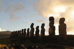
Google Earth 3d view/aerial satellite map view/hybrid satellite maps/road map of Easter Island, Chile
|
|
|
|
|
|
|
|
|
|
Submitted by jos on Sun, 07/25/2010 - 00:15
|
Google Earth 3d view/aerial satellite map view/hybrid satellite maps/road map of Cape of Good Hope, Cape Point, South Africa
|
|
|
|
|
|
|
|
|
|
Submitted by jos on Sun, 07/25/2010 - 00:01
|
Google Earth 3d view/aerial satellite map view/hybrid satellite maps/road map of Mt Everest, Nepal
|
|
|
|
|
|
|
|
|
|
Submitted by jos on Sat, 07/24/2010 - 23:49
|
Google Earth 3d view/aerial satellite map view/hybrid satellite maps/road map of Qutub Minar, Vasant Kunj, New Delhi, Haryana, India
|
|
|
|
|
|
|
|
|
|
Submitted by yezzbi on Thu, 06/10/2010 - 01:30
|
Google Earth 3d view/ aerial satellite map view/ hybrid satellite maps/ road map of mbombela stadium, nelspruit, south africa
|
|
|
|
|
|
|
|
|
|
Submitted by yezzbi on Thu, 06/10/2010 - 01:16
|
Google streetview of Royal Bafokeng Stadium, Rustenburg, South Africa
|
|
|
|
|
|
|
|
|
|
Submitted by yezzbi on Thu, 06/10/2010 - 00:51
|
Google Street view of Peter Mokaba Stadium, Polokwane from within stadium
|
|
|
|
|
|
|
|
|
|
Submitted by yezzbi on Wed, 06/09/2010 - 23:39
|
Google Earth 3d view/ aerial satellite map view/ hybrid satellite maps/ road map of bloemfontein south africa free state stadium
|
|
|
|
|

|
|

