|
|
|
|
|
|
Submitted by admin28k on Wed, 01/01/2014 - 16:23
|
Various tools available in Geographical Area Measurement Tool is expalined below.
Search for a place using "place search tool"

For marking a region use the geographical marker toolbox on top of the map. There are tools like rectangle, circle, polyline, polygrid to mark suitably

Change color of a selected region by choosing one color from color bar below

|
|
|
|
|
|
|
|
|
|
Submitted by Ria on Sun, 12/29/2013 - 02:48
|
Google Maps Area Calculator Tool (Planimeter)
palm jumeira circle middle portion marked with shape tool from tool box

The area measurement of palm jumeira circle middle portion

Find area of a plot, land, geographical region using Google mapping technology,high tech way in a Fast, easy way with power.
|
|
|
|
|
|
|
|
|
|
Submitted by Jackie on Tue, 08/10/2010 - 01:09
|
* Bethlehem view
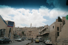
* Wall surrounding Bethlehem seperates palastine from Israel
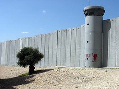
* Images courtesy Flickr.com and its vibrant members
Google Earth 3d view/aerial satellite map view/hybrid satellite maps/road map of Bethlehem, Birth place of Jesus Christ follows
|
|
|
|
|
|
|
|
|
|
Submitted by Greenived on Sun, 11/15/2009 - 20:21
|
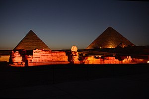
The great sphinx
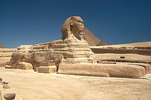
The Great Sphinx of Giza against Khafre's Pyramid at the Giza pyramid complex.
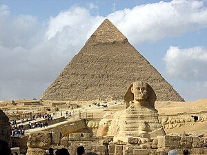

Night view of pyramids
|
|
|
|
|
|
|
|
|
|
Submitted by jos on Fri, 03/08/2013 - 06:20
|
Google Earth 3d view/aerial satellite map view/hybrid satellite maps/road map of Venezuela
|
|
|
|
|
|
|
|
|
|
Submitted by jos on Fri, 03/08/2013 - 05:29
|
Google Earth 3d view/aerial satellite map view/hybrid satellite maps/road map of Aruba
|
|
|
|
|
|
|
|
|
|
Submitted by jaxo on Tue, 07/03/2012 - 02:03
|
According to Hindu mythology, this lake was created by King Ravana for the express purpose of garnering superpowers through acts of devotion and meditation to the Lord Shiva who was presiding on Mount Kailash. It was upon the banks of a special island in this lake that he would make daily offering with one of his ten heads as a sacrifice to please the Lord Shiva. Finally, on the tenth day, Lord Shiva was moved enough by his devotion and granted Ravana his wish to obtain superpowers. This lake is set as a contrast to the holy god-created Lake Manasarovar.
Google Earth 3d view/aerial satellite map view/hybrid satellite maps/road map of Lake Rakshastal
|
|
|
|
|
|
|
|
|
|
Submitted by jaxo on Tue, 07/03/2012 - 01:56
|
Google Earth 3d view/aerial satellite map view/hybrid satellite maps/road map of lake manasa sarovar
|
|
|
|
|
|
|
|
|
|
Submitted by jaxo on Tue, 07/03/2012 - 00:38
|
Google Earth 3d view/aerial satellite map view/hybrid satellite maps/road map of Kailash Mountain
|
|
|
|
|
|
|
|
|
|
Submitted by Ria on Fri, 06/01/2012 - 05:10
|
Church of the Nativity in Bethlehem is one of the oldest continuously operating churches in the world. located in palestine .
|
|
|
|
|
|
|
|
|
|
Submitted by jos on Sun, 01/29/2012 - 20:33
|
Google Earth 3d view/aerial satellite map view/hybrid satellite maps/road map of San Jose International Airport (SJC), 1659 Airport Blvd, San Jose, CA 95110, USA
|
|
|
|
|
|
|
|
|
|
Submitted by jos on Sun, 01/29/2012 - 20:31
|
Google Earth 3d view/aerial satellite map view/hybrid satellite maps/road map of San Jose, CA, USA
|
|
|
|
|
|
|
|
|
|
Submitted by jos on Sun, 01/29/2012 - 20:24
|
Google Earth 3d view/aerial satellite map view/hybrid satellite maps/road map of San Diego, CA, USA
|
|
|
|
|
|
|
|
|
|
Submitted by jos on Sun, 01/29/2012 - 20:13
|
Google Earth 3d view/aerial satellite map view/hybrid satellite maps/road map of San Diego International Airport, CA, USA
|
|
|
|
|
|
|
|
|
|
Submitted by jos on Sun, 01/29/2012 - 20:01
|
Google Earth 3d view/aerial satellite map view/hybrid satellite maps/road map of Los Angeles, USA
|
|
|
|
|
|
|
|
|
|
Submitted by ronjs on Sun, 01/29/2012 - 18:51
|
Image of Strait of Hormus, Iran* Straße von Hormus 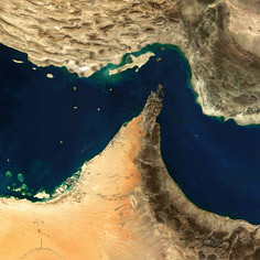 * Images courtesy Flickr.com and its vibrant members
Google Earth * Images courtesy Flickr.com and its vibrant members
Google Earth 3d view/ aerial satellite map view/hybrid satellite maps/road map of Strait of Hormuz, Iran follows
|
|
|
|
|
|
|
|
|
|
Submitted by ronjs on Sun, 01/29/2012 - 16:47
|
Google Earth 3d view/aerial satellite map view/hybrid satellite maps/road map of Petra, Jordan
|
|
|
|
|
|
|
|
|
|
Submitted by jos on Sat, 01/07/2012 - 07:00
|
Google Earth 3d view/aerial satellite map view/hybrid satellite maps/road map of Angel Falls, Venezuela
|
|
|
|
|
|
|
|
|
|
Submitted by jos on Wed, 12/28/2011 - 07:43
|
Maui is part of the state of Hawaii,second largest Hawaiian Island famous for tourist attractions.
|
|
|
|
|
|
|
|
|
|
Submitted by X-Ray2 on Sat, 12/24/2011 - 02:52
|
Google Earth 3d view/aerial satellite map view/hybrid satellite maps/road map of Sea of Galilee
|
|
|
|
|
|
|
|
|
|
Submitted by jos on Sun, 12/11/2011 - 06:24
|
Google Earth 3d view/aerial satellite map view/hybrid satellite maps/road map of Hudson Bay
|
|
|
|
|
|
|
|
|
|
Submitted by jos on Sun, 12/11/2011 - 06:02
|
Google Earth 3d view/aerial satellite map view/hybrid satellite maps/road map of College of Southern Idaho, Twin Falls, USA
|
|
|
|
|
|
|
|
|
|
Submitted by jos on Sun, 12/11/2011 - 05:39
|
Google Earth 3d view/aerial satellite map view/hybrid satellite maps/road map of Gulf of California, USA
|
|
|
|
|
|
|
|
|
|
Submitted by jos on Sun, 12/11/2011 - 05:24
|
Google Earth 3d view/aerial satellite map view/hybrid satellite maps/road map of Gulf of Mexico
|
|
|
|
|
|
|
|
|
|
Submitted by jos on Sun, 12/11/2011 - 05:08
|
Google Earth 3d view/aerial satellite map view/hybrid satellite maps/road map of Haiti follows
|
|
|
|
|
|
|
|
|
|
Submitted by jos on Sun, 12/11/2011 - 05:00
|
Google Earth 3d view/aerial satellite map view/hybrid satellite maps/road map of West Indies
|
|
|
|
|
|
|
|
|
|
Submitted by jos on Sun, 12/11/2011 - 02:47
|
Google Earth 3d view/aerial satellite map view/hybrid satellite maps/road map of Dominican Republic
|
|
|
|
|
|
|
|
|
|
Submitted by jos on Sun, 12/11/2011 - 02:29
|
Google Earth 3d view/aerial satellite map view/hybrid satellite maps/road map of Puerto Rico
|
|
|
|
|
|
|
|
|
|
Submitted by jos on Sun, 12/11/2011 - 01:58
|
Google Earth 3d view/aerial satellite map view/hybrid satellite maps/road map of Bahamas follows
|
|
|
|
|
|
|
|
|
|
Submitted by jos on Sun, 12/11/2011 - 01:22
|
Cuba is an Island Nation in Caribbean, famous because of its communist rule very near to Capitalist American rule and thereby rivalry with America.
* Che Statue at Santa Clara PCC_Cuba 239
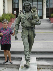
* Cuba
* Cuba
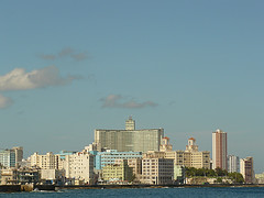
* Images courtesy Flickr.com and its vibrant members
Google Earth 3d view/aerial satellite map view/hybrid satellite maps/road map of Cuba follows ...
|
|
|
|
|

|
|

