|
|
|
|
|
|
Submitted by jaxo on Wed, 07/04/2012 - 01:39
|
Images of samsung galaxy s3
|
|
|
|
|
|
|
|
|
|
Submitted by jaxo on Tue, 07/03/2012 - 02:03
|
According to Hindu mythology, this lake was created by King Ravana for the express purpose of garnering superpowers through acts of devotion and meditation to the Lord Shiva who was presiding on Mount Kailash. It was upon the banks of a special island in this lake that he would make daily offering with one of his ten heads as a sacrifice to please the Lord Shiva. Finally, on the tenth day, Lord Shiva was moved enough by his devotion and granted Ravana his wish to obtain superpowers. This lake is set as a contrast to the holy god-created Lake Manasarovar.
Google Earth 3d view/aerial satellite map view/hybrid satellite maps/road map of Lake Rakshastal
|
|
|
|
|
|
|
|
|
|
Submitted by jaxo on Tue, 07/03/2012 - 01:56
|
Google Earth 3d view/aerial satellite map view/hybrid satellite maps/road map of lake manasa sarovar
|
|
|
|
|
|
|
|
|
|
Submitted by jaxo on Tue, 07/03/2012 - 00:38
|
Google Earth 3d view/aerial satellite map view/hybrid satellite maps/road map of Kailash Mountain
|
|
|
|
|
|
|
|
|
|
Submitted by Ria on Fri, 06/01/2012 - 07:00
|
The Terraces of the Bahá'í Faith, also known as the Hanging Gardens of Haifa, are garden terraces around the Shrine of the Báb on Mount Carmel in Haifa, Israel. They are one of the most visited tourist attractions in Israel. The architect is Fariborz Sahba from Iran, the structural engineers are Karban and Co. from Haifa. Along with the Baha'i Holy Places in Western Galilee, it is a UNESCO World Heritage Site.
Images, Videos, Google Earth satellite maps, Google street views of Bahais Garden follows. continue reading
|
|
|
|
|
|
|
|
|
|
Submitted by Ria on Fri, 06/01/2012 - 05:10
|
Church of the Nativity in Bethlehem is one of the oldest continuously operating churches in the world. located in palestine .
|
|
|
|
|
|
|
|
|
|
Submitted by jos on Tue, 05/01/2012 - 07:45
|
New York University (NYU) is a private research university based in New York City, it is founded in 1831 and is one of the largest private, nonprofit institutions of higher education in the United States.
|
|
|
|
|
|
|
|
|
|
Submitted by DaneC on Wed, 02/08/2012 - 04:54
|
* Dubai at night

* Images courtesy Flickr.com and its vibrant members
Images, Videos, Google Earth 3d view/aerial satellite map view/hybrid satellite maps/road map of Maritime City, Dubai - United Arab Emirates (الصور وأشرطة الفيديو، برنامج Google Earth 3D رأي / جوي عرض الخريطة الفضائية / خرائط الأقمار الصناعية المختلطة / خارطة الطريق من المدينة البحرية، دبي - الامارات العربية المتحدة) follows
|
|
|
|
|
|
|
|
|
|
Submitted by JacobYK on Wed, 02/08/2012 - 00:23
|
* Stopping during desert safari for viewing sunset
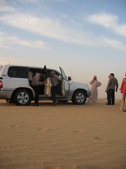
*image courtesy Flickr.com and its vibrant community and its members
Images, Videos, Google Earth 3d view/aerial satellite map view/hybrid satellite maps/road map of Global Village Dubai, United Arab Emirates follows
|
|
|
|
|
|
|
|
|
|
Submitted by jos on Sun, 01/29/2012 - 20:33
|
Google Earth 3d view/aerial satellite map view/hybrid satellite maps/road map of San Jose International Airport (SJC), 1659 Airport Blvd, San Jose, CA 95110, USA
|
|
|
|
|
|
|
|
|
|
Submitted by jos on Sun, 01/29/2012 - 20:31
|
Google Earth 3d view/aerial satellite map view/hybrid satellite maps/road map of San Jose, CA, USA
|
|
|
|
|
|
|
|
|
|
Submitted by jos on Sun, 01/29/2012 - 20:24
|
Google Earth 3d view/aerial satellite map view/hybrid satellite maps/road map of San Diego, CA, USA
|
|
|
|
|
|
|
|
|
|
Submitted by jos on Sun, 01/29/2012 - 20:13
|
Google Earth 3d view/aerial satellite map view/hybrid satellite maps/road map of San Diego International Airport, CA, USA
|
|
|
|
|
|
|
|
|
|
Submitted by jos on Sun, 01/29/2012 - 20:01
|
Google Earth 3d view/aerial satellite map view/hybrid satellite maps/road map of Los Angeles, USA
|
|
|
|
|
|
|
|
|
|
Submitted by ronjs on Sun, 01/29/2012 - 18:51
|
Image of Strait of Hormus, Iran* Straße von Hormus 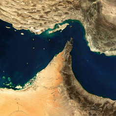 * Images courtesy Flickr.com and its vibrant members
Google Earth * Images courtesy Flickr.com and its vibrant members
Google Earth 3d view/ aerial satellite map view/hybrid satellite maps/road map of Strait of Hormuz, Iran follows
|
|
|
|
|
|
|
|
|
|
Submitted by ronjs on Sun, 01/29/2012 - 16:47
|
Google Earth 3d view/aerial satellite map view/hybrid satellite maps/road map of Petra, Jordan
|
|
|
|
|
|
|
|
|
|
Submitted by jos on Sat, 01/07/2012 - 07:00
|
Google Earth 3d view/aerial satellite map view/hybrid satellite maps/road map of Angel Falls, Venezuela
|
|
|
|
|
|
|
|
|
|
Submitted by jos on Wed, 12/28/2011 - 07:43
|
Maui is part of the state of Hawaii,second largest Hawaiian Island famous for tourist attractions.
|
|
|
|
|
|
|
|
|
|
Submitted by X-Ray2 on Sat, 12/24/2011 - 02:52
|
Google Earth 3d view/aerial satellite map view/hybrid satellite maps/road map of Sea of Galilee
|
|
|
|
|
|
|
|
|
|
Submitted by jos on Sun, 12/11/2011 - 06:24
|
Google Earth 3d view/aerial satellite map view/hybrid satellite maps/road map of Hudson Bay
|
|
|
|
|
|
|
|
|
|
Submitted by jos on Sun, 12/11/2011 - 06:02
|
Google Earth 3d view/aerial satellite map view/hybrid satellite maps/road map of College of Southern Idaho, Twin Falls, USA
|
|
|
|
|
|
|
|
|
|
Submitted by jos on Sun, 12/11/2011 - 05:39
|
Google Earth 3d view/aerial satellite map view/hybrid satellite maps/road map of Gulf of California, USA
|
|
|
|
|
|
|
|
|
|
Submitted by jos on Sun, 12/11/2011 - 05:24
|
Google Earth 3d view/aerial satellite map view/hybrid satellite maps/road map of Gulf of Mexico
|
|
|
|
|
|
|
|
|
|
Submitted by jos on Sun, 12/11/2011 - 05:08
|
Google Earth 3d view/aerial satellite map view/hybrid satellite maps/road map of Haiti follows
|
|
|
|
|
|
|
|
|
|
Submitted by jos on Sun, 12/11/2011 - 05:00
|
Google Earth 3d view/aerial satellite map view/hybrid satellite maps/road map of West Indies
|
|
|
|
|
|
|
|
|
|
Submitted by jos on Sun, 12/11/2011 - 02:47
|
Google Earth 3d view/aerial satellite map view/hybrid satellite maps/road map of Dominican Republic
|
|
|
|
|
|
|
|
|
|
Submitted by jos on Sun, 12/11/2011 - 02:29
|
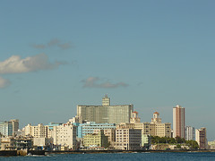
Google Earth 3d view/aerial satellite map view/hybrid satellite maps/road map of Puerto Rico
|
|
|
|
|
|
|
|
|
|
Submitted by jos on Sun, 12/11/2011 - 01:58
|
Google Earth 3d view/aerial satellite map view/hybrid satellite maps/road map of Bahamas follows
|
|
|
|
|
|
|
|
|
|
Submitted by jos on Sun, 12/11/2011 - 01:22
|
Cuba is an Island Nation in Caribbean, famous because of its communist rule very near to Capitalist American rule and thereby rivalry with America.
* Che Statue at Santa Clara PCC_Cuba 239
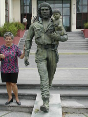
* Cuba
* Cuba
* Images courtesy Flickr.com and its vibrant members
Google Earth 3d view/aerial satellite map view/hybrid satellite maps/road map of Cuba follows ...
|
|
|
|
|
|
|
|
|
|
Submitted by jos on Sat, 12/10/2011 - 18:02
|
* The Bermuda Triangle
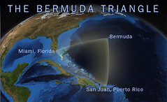
* Images courtesy Flickr.com and its vibrant members
Google Earth 3d view/aerial satellite map view/hybrid satellite maps/road map of Bermuda Triangle follows, click Read more
|
|
|
|
|

|
|

