|
|
|
|
|
|
Submitted by jos on Sat, 03/05/2011 - 01:45
|
Google Earth 3d view/aerial satellite map view/hybrid /road map of Auckland, New Zealand
|
|
|
|
|
|
|
|
|
|
Submitted by jos on Sat, 03/05/2011 - 01:12
|
Google Earth 3d view/aerial satellite map view/hybrid /road map of Libya
|
|
|
|
|
|
|
|
|
|
Submitted by jos on Sat, 03/05/2011 - 01:02
|
3d view/aerial satellite map view/hybrid /road map of Oman
|
|
|
|
|
|
|
|
|
|
Submitted by Ria on Tue, 08/31/2010 - 01:41
|
Wonosobo is a regency in central java province of Indonesia which is located in Dieng Plateau about 120km from semarang .
|
|
|
|
|
|
|
|
|
|
Submitted by Ramkumar on Tue, 08/31/2010 - 00:57
|
Mount Rinjani or Gunung Rinjani on the island of Lombok West Nusa Tenggara (NTB)is an active volcano in Indonesia. It has high height of 3,726 metres (12,224 ft),being the second highest volcano in Indonesia.
Its 6 km long 8.5 km width oval-shaped caldera containing hot springs is filled partially by 200 meter depth crater lake known as Segara Anak ('Child of the Sea'). This lake is approximately 2000 metres above sea level.
Google Earth 3d view/ satellite map view/hybrid satellite maps/road map of Mount Rinjani.
|
|
|
|
|
|
|
|
|
|
Submitted by jos on Tue, 08/31/2010 - 00:27
|
Lake Maninjau in Indonesian language called Danau Maninjau, means overlook or observation is a caldera crater formed lake in West Sumatra, Indonesia. It is 16 km near to the city of Bukittinggi in Sumatra. It is estimated to have formed 50000 years ago and has 20x8 km length and width.People who live are mostly ethnic Minangkabau.Lake Maninjau is used for hydro electric power generation and has aquaculture farm production. Lake Maninjau is big tourist attraction in the region because of its splendid scenic beauty. Sport activities like trekking paragliding attracts adventurists too.
Google Earth 3d view/ satellite map view/hybrid satellite maps/road map of Lake Maninjau.
|
|
|
|
|
|
|
|
|
|
Submitted by Ramkumar on Mon, 08/30/2010 - 23:47
|
jam gadang big clock tower in Bukittinggi, as shown in google earth
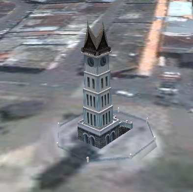
Bukittinggi means in Indonesian language "high hill" is one of the larger cities in West Sumatra, Indonesia, which is 90 km by road distance from the West Sumatran capital city of Padang. It is having a population of over 91,000 people and an area of 25.24 km².
It is a city popular with tourists due to the climate and easy accessibility. Attractions within and around the city follows:
*Sianok Canyon
* Ngarai Sianok (Sianok Canyon)
* Lobang Jepang (Japanese Caves) - a network of underground bunkers and tunnels built by the Japanese during World War II
* Jam Gadang - a large clock tower built by the Dutch .
* Taman Bundo Kanduang park. The Dutch hilltop outpost Fort de Kock is connected to the zoo by the Limpapeh pedestrian pass.
* Museum Rumah Kelahiran Bung Hatta, the house where Indonesian founding father Mohammad Hatta was born, now a museum.
Nearby Tourist attractions include Lake Maninjau and the Harau Valley.
Google Earth 3d view/ satellite map view/hybrid satellite maps/road map of Bukittinggi, Indonesia
|
|
|
|
|
|
|
|
|
|
Submitted by rahmat on Mon, 08/30/2010 - 22:58
|
Google Earth 3d view/ satellite map view/hybrid satellite maps/road map of Mt Bromo, Sukapura.
|
|
|
|
|
|
|
|
|
|
Submitted by jos on Mon, 08/30/2010 - 22:34
|
Wikimapia satellite map of Bekasi of west java island in Indonesia
|
|
|
|
|
|
|
|
|
|
Submitted by Ramkumar on Mon, 08/30/2010 - 21:44
|
Google Earth 3d view/aerial satellite map view/hybrid satellite maps/road map of Central Java (Indonesian name java Tengah) of Indonesia which is one of the six provinces in island of jawa
|
|
|
|
|
|
|
|
|
|
Submitted by jos on Tue, 07/27/2010 - 00:34
|
Google Earth 3d view/aerial satellite map view/hybrid satellite maps/road map of Luxor, Al - Uqsur, Qena, Egypt
|
|
|
|
|
|
|
|
|
|
Submitted by jos on Tue, 07/27/2010 - 00:21
|
Google Earth 3d view/aerial satellite map view/hybrid satellite maps/road map of Cairo, Egypt
|
|
|
|
|
|
|
|
|
|
Submitted by jos on Tue, 07/27/2010 - 00:08
|
Google Earth 3d view/aerial satellite map view/hybrid satellite maps/road map of Egypt
|
|
|
|
|
|
|
|
|
|
Submitted by jos on Mon, 07/26/2010 - 02:40
|
The World is an artificial archipelago of various small islands constructed in the rough shape of a map of the landmasses of the Earth, located 4 km from the coast of Dubai, United Arab Emirates. The World islands are composed mainly of sand dredged from Dubai's shallow coastal waters, and are one of several artificial island developments in Dubai. The World's developer is Nakheel Properties, and the project was originally conceived by Sheikh Mohammed bin Rashid Al Maktoum, the ruler of Dubai.
Google Earth 3d view/aerial satellite map view/hybrid satellite maps/road map of The World Dubai follows
|
|
|
|
|
|
|
|
|
|
Submitted by jos on Sun, 07/25/2010 - 00:46
|
|
|
|
|
|
|
|
|
|
|
Submitted by jos on Sun, 07/25/2010 - 00:30
|
Sunrise of New Year 2009 at Easter Island
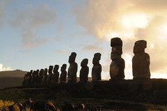
Google Earth 3d view/aerial satellite map view/hybrid satellite maps/road map of Easter Island, Chile
|
|
|
|
|
|
|
|
|
|
Submitted by jos on Sun, 07/25/2010 - 00:15
|
Google Earth 3d view/aerial satellite map view/hybrid satellite maps/road map of Cape of Good Hope, Cape Point, South Africa
|
|
|
|
|
|
|
|
|
|
Submitted by jos on Sun, 07/25/2010 - 00:01
|
Google Earth 3d view/aerial satellite map view/hybrid satellite maps/road map of Mt Everest, Nepal
|
|
|
|
|
|
|
|
|
|
Submitted by jos on Sat, 07/24/2010 - 23:49
|
Google Earth 3d view/aerial satellite map view/hybrid satellite maps/road map of Qutub Minar, Vasant Kunj, New Delhi, Haryana, India
|
|
|
|
|
|
|
|
|
|
Submitted by Ramkumar on Sat, 06/26/2010 - 22:53
|
Bloemfontein Airport Google Satellite maps
|
|
|
|
|
|
|
|
|
|
Submitted by jaxo on Sat, 06/26/2010 - 19:15
|
google earth maps/ google satellite maps/hybrid view of cape town south africa airport.
|
|
|
|
|
|
|
|
|
|
Submitted by jaxo on Sat, 06/12/2010 - 23:11
|
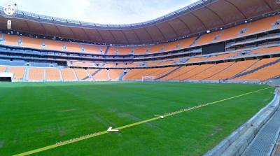
Google Street view of Soccer city stadium johannesburg SA
Google gives great coverage to 2010 Fifa world cup through all its services. As part of it Google has newly introduced their popular Street view Service in South Africa just before the Fifa World cup 2010 kick off start. Google Street view is available in most of the South africa streets except the north eastern locations. South Africa becomes the first african continent country where Google Street view currently available apart from Gran Canaria islands. The most interesting part is that Google has covered the inside of Fifa world cup stadiums too.
Follow the rest of story by clicking read more
|
|
|
|
|
|
|
|
|
|
Submitted by yezzbi on Thu, 06/10/2010 - 01:30
|
Google Earth 3d view/ aerial satellite map view/ hybrid satellite maps/ road map of mbombela stadium, nelspruit, south africa
|
|
|
|
|
|
|
|
|
|
Submitted by yezzbi on Thu, 06/10/2010 - 01:16
|
Google streetview of Royal Bafokeng Stadium, Rustenburg, South Africa
|
|
|
|
|
|
|
|
|
|
Submitted by yezzbi on Thu, 06/10/2010 - 00:51
|
Google Street view of Peter Mokaba Stadium, Polokwane from within stadium
|
|
|
|
|
|
|
|
|
|
Submitted by yezzbi on Wed, 06/09/2010 - 23:39
|
Google Earth 3d view/ aerial satellite map view/ hybrid satellite maps/ road map of bloemfontein south africa free state stadium
|
|
|
|
|
|
|
|
|
|
Submitted by yezzbi on Wed, 06/09/2010 - 22:42
|
Google Earth 3d view/ aerial satellite map view/ hybrid satellite maps/ road map of nelson mandela bay stadium,6001, port elizabeth , south africa
|
|
|
|
|
|
|
|
|
|
Submitted by yezzbi on Mon, 06/07/2010 - 00:01
|
Google Earth 3d view/aerial satellite map view/hybrid satellite maps/road map of Loftus Versfeld Soccer Stadium, Pretoria 0002, South Africa
|
|
|
|
|
|
|
|
|
|
Submitted by yezzbi on Sun, 06/06/2010 - 23:23
|
Google Earth 3d view/aerial satellite map view/hybrid satellite maps/road map of Ellis Park Soccer Stadium - Parking Area, 44 Staib St, Johannesburg 2094, South Africa
|
|
|
|
|
|
|
|
|
|
Submitted by yezzbi on Sun, 06/06/2010 - 22:43
|
Google Earth 3d view/aerial satellite map view/hybrid satellite maps/road map of Green Point Stadium, Cape Town 8005, South Africa
|
|
|
|
|

|
|